During the Italian fascist occupation of Ethiopia (1936-1941) the authorities considered the idea of moving the capital to the low lands and nearer the sea. But this idea was not accepted by Mussolini, the head of the fascist government, and a “grandiose plan” to change the settlement pattern of Addis Ababa was worked out in 1939 (Bahru Zewde, 1986:14).
Richard Pankhurst (1986:23-26) has described chronologically the master plan proposals of various professionals for Addis Ababa. According to his study the architects who were commissioned by Mussolini to prepare “the general master plan” were Marcello Piacentini, Archur Bianchi, Enrico Del Debbio and Giuseppe Vaccaro in addition to Le Corbusier and Guidi-Valle. The proposed plans of these professionals were basically different in the character of the architecture and the general structure of the city (Dandena Tuffa, 1995:35). These characteristics are due to the proposed imposition of new planning concepts on the existing old settlement.
Out of these proposals we have two notable plans that were prepared during the five-year occupation. The first sketch was prepared by Le Corbuiser, a Swiss – French national, who at the invitation of Mussolini prepared a guideline for a master plan of Addis Ababa in 1936. His plan shows his idea of a city as “an instrument of work, command center and seat of government” which serves the needs of constructing large office buildings and modern dwellings for the colonial masters (CIPIA, 1992 as cited in Dandena, 1995).
Had Le Corbusier’s sketch for the colonial capital of Addis Ababa been realized, it would have been one of the most ruthlessly planned cities of the twentieth century. On the 19th of August 1936 (a mere three months after the conquest of Addis Ababa), Le Corbusier wrote to Mussolini to offer his technical services and to comment on the appropriate design for the new cities of Africa Orientale Italiana, the Italian colonial empire.
The shortcomings of his proposal, according to Dandena (1999:40), were first that the plan did not take into account the topography of the city, second, that the residential sector was designed with square grids of street patterns irrespective of the land configuration and the existing streams. Third, the four articulated regional roads were designed geometrically where their direction of movement did not fit into the then constructed five regional highways. Lastly his work did not take into account the existing structure of the city.
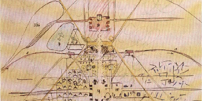
The second notable proposed master plan was prepared by Guidi and Valle in the summer 1936 which was approved by Grazziani, governor and viceroy of Italian East Africa, on October of the same year (CIPIA, 1992 as cited in Dandena, 1995). Its model of rigid segregation between the native and the Europeans characterizes the main concept of the plan, which was an integral part of their racial and discriminatory policy. By this “Piano Regulatore” (town planning) Addis Ababa was divided into two settlement zones, namely the native quarter and the Italian quarter.
The native quarter was located to the west of Addis Ababa known as Addis Ketema whereas the Italian quarter was located largely to the east and south of Addis Ababa. During the implementation of the segregation policy, the native city was further divided into Christian and Muslim and with in the Christian quarter, there was separate land allocated for tribal groups such as Oromo, Amhara, Tigre, etc.,which was derived from the regional administration of the country (Tekeste Ahdrom, 1986)
According to Pankhurst (1986:25) the new plan left the old “chaotic” area around St. George Cathedral unchanged and shifted the city center southwards to the city center were the Dire Dawa- Jimma and Asmara- Addis Ababa roads meet. This area was reserved for “politico-administrative activity” and the nucleus of the new city. The European residence area was located to the east of the Palace hill and the commercial activities and a municipal office were located on the West Side of the Place hill. The industrial zones were located to the south of the railway station and the “native” city lies to the west separated by unoccupied areas of vegetation and riverbeds.
The implementation of this master plan is considered to be the first urban development–induced displacement.
Source: Excerpt from Nebiyu Baye (2000). The impact of development-induced urban resettlement schemes on relocated households. MA Thesis. Addis Ababa University


